Need drone RLs and level views for a development?
Flying Glass captures precise drone RLs and level views for property developers, architects, builders, planning consultants, visualisation studios and real estate marketing teams across Australia.
We fly drones to specific Reduced Levels, floor heights or proposed apartment levels so your team can show the future view before the building exists. These images can support architectural renders, off-the-plan sales, planning submissions, investor presentations and view impact assessments.
Book Drone RLs and Level Views
Drone RLs and Level Views for Architects, Developers and Render Studios
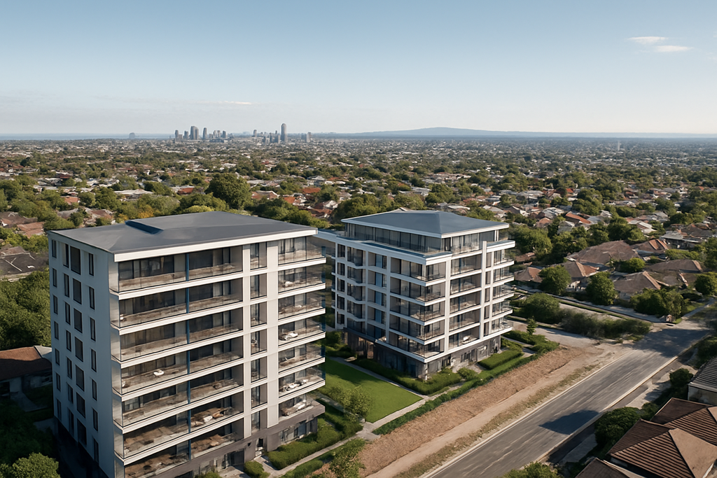
At Flying Glass, we specialise in capturing drone RLs and level views for architects, property developers, building companies, planning consultants and visualisation studios across Australia. These images help project teams show buyers, councils, investors and stakeholders what the future view will look like from each level of a proposed development.
In a competitive property market, a clear view can make an enormous difference. If a future apartment, hotel room, rooftop terrace or commercial space will have ocean views, skyline views, district views or a particular outlook, your marketing and design team needs to show that accurately before construction begins.
Our drone RLs and level views service gives your team real imagery captured from the correct height. This can be used in architectural renders, planning reports, sales campaigns, visual impact studies, DA documentation and investor materials.
Instead of relying entirely on simulated views, street-level guesses or generic aerials, drone RLs and level views allow you to ground your project visuals in real, site-specific imagery.
What Are Drone RLs and Level Views?
Drone RLs and level views are height-based drone photographs or videos captured at specific Reduced Levels, also known as RLs. An RL is a measured height used in architectural, planning and construction documentation.
For a proposed building, your architect or surveyor may provide RLs for each level, apartment, balcony, rooftop or key viewpoint. Flying Glass can then fly a drone to those heights and capture the view from each nominated position.
These images are commonly used to show:
- The future view from each apartment level
- Views from balconies, terraces and rooftop areas
- Outlooks from proposed hotel rooms or commercial spaces
- View corridors from a future development
- Visual impact from specific heights
- Real-world context for architectural renders
- Marketing imagery for off-the-plan sales
Drone RLs and level views are especially useful before construction begins, when developers need to demonstrate what buyers, councils or investors will see from a building that does not yet exist.
Show the Future View Before the Building Exists
The real value of drone RLs and level views is simple: they help your team show the future.
For off-the-plan buyers, the view can be one of the biggest drivers of perceived value. A premium apartment may achieve a stronger result if buyers can clearly understand the outlook from Level 6, Level 10 or the penthouse. For developers, accurate drone level views can support pricing, sales conversations and campaign confidence.
For architects and render studios, drone RLs and level views provide real-world photographic material that can be integrated into renders, photomontages and visualisation packages. This helps the final imagery feel more credible, more accurate and more site-specific.
For planning consultants, drone level views can support view sharing analysis, visual impact reports, design review documentation and stakeholder communication.
Who Uses Drone RLs and Level Views?
Our drone RLs and level views service is used across the Australian property, architecture, construction and visualisation industries.
Typical clients include:
- Property developers preparing off-the-plan sales campaigns
- Architects developing visual material for design and planning
- Render studios needing real view plates for 3D imagery
- Building companies preparing stakeholder presentations
- Town planners preparing development application material
- Real estate marketers promoting premium apartments
- Visualisation teams building accurate project imagery
- Landscape architects assessing outlook and view corridors
- Environmental consultants preparing visual impact studies
- Councils and urban designers reviewing development impacts
- Investment teams preparing feasibility or funding material
Drone RLs and level views are useful wherever a project team needs to understand, explain or market the view from a proposed future height.
Why Drone RLs Are Essential for Property Developers
For developers, drone RLs and level views can support the commercial story of a project. A future view is not just a design detail. It can influence pricing, buyer confidence, investor appetite and marketing strength.
Drone RLs and level views can help developers:
- Demonstrate views before construction begins
- Support off-the-plan apartment sales
- Show buyers the difference between lower and upper levels
- Provide real imagery for brochures, websites and display suites
- Give sales teams stronger visual material
- Support investor and financier presentations
- Show the value of premium outlooks
- Provide accurate reference material for renders
- Improve confidence in pricing and positioning
When buyers can see the likely view from a specific level, they have a clearer sense of what they are purchasing. This is especially important for coastal developments, high-rise apartments, waterfront sites, city towers and premium residential projects.
Drone Level Views for Architects
Architects use drone RLs and level views to better understand the relationship between a proposed building and its surroundings. Height-based drone photography can help design teams assess outlook, orientation, neighbouring structures, landscape features and potential visual constraints.
Drone RLs and level views can support architects with:
- Concept design
- Design development
- View corridor assessment
- Client presentations
- DA imagery
- Photomontage reference material
- Rooftop and balcony outlook studies
- Site context analysis
- Coordination with render studios
Flying Glass can work from architectural plans, RL schedules, marked-up drawings or a simple list of required floor heights. We can also liaise directly with your project architect or visualisation team to ensure the imagery is captured in the right direction, format and sequence.
Drone Photography for Architectural Renders
One of the most common uses for drone RLs and level views is architectural rendering. Render studios need accurate view plates, context imagery and background photography to create credible project visuals.
By capturing drone photographs from nominated RLs, Flying Glass helps visualisation teams produce renders that reflect the real outlook from the proposed building. This is far more useful than generic aerial photography because the image is captured from the height and direction required for the project.
Drone RLs and level views can be supplied for:
- Apartment view renders
- Balcony outlook renders
- Penthouse marketing visuals
- Hotel room views
- Rooftop terrace imagery
- Commercial office outlooks
- Mixed-use precinct renders
- Sales suite displays
- Interactive project websites
We can capture stills, panoramas, 360-degree views or video footage depending on the needs of the render workflow.
Our Process for Drone RLs and Level Views
Flying Glass makes the process straightforward for busy project teams. We understand that developers, architects and render studios often need this material quickly, clearly and without unnecessary back and forth.
Our process usually works like this:
- You send the site details: including the address, access notes and any known timing requirements.
- You provide the RLs or floor heights: this may be an RL schedule, architectural plan, marked-up drawing or simple list of heights.
- We confirm the shot requirements: including direction, angle, stills, video, panoramas or 360-degree views.
- We conduct airspace and site checks: including CASA requirements, access, weather and operational constraints.
- We capture the drone RLs and level views: flying to the specified heights and documenting the requested outlooks.
- We deliver organised files: labelled by level, height, direction or agreed naming convention.
Our goal is to make drone RLs and level views easy for your team to use. We can match your required naming convention, preferred file format and delivery structure so the images flow smoothly into your render, marketing or planning workflow.
What We Need From You
To quote and plan drone RLs and level views accurately, we usually need:
- The site address
- The required date or deadline
- The RLs, floor heights or nominated viewpoints
- The number of levels or positions required
- The required directions, such as north, south, east and west
- Whether you need stills, video, panoramas or 360-degree imagery
- Any access instructions or site restrictions
- Any preferred file naming or delivery requirements
If you do not have everything ready, that is fine. We can often work with preliminary information and help you identify what is needed before the shoot.
Why Accuracy Matters for Drone RLs and Level Views
Drone RLs and level views need to be captured carefully because small height or direction errors can create confusion later. If imagery is being used for architectural renders, sales material or planning documentation, it needs to be organised and reliable.
Flying Glass uses professional drone equipment, flight logging systems and experienced pilots to capture height-based imagery with care. We understand that the files may be used by several different teams, including architects, developers, marketers, render artists and consultants.
Accuracy matters because drone RLs and level views can influence:
- Buyer expectations
- Sales presentations
- Architectural visualisations
- Planning discussions
- Visual impact assessments
- Investor confidence
- Marketing claims
We take a methodical approach so your team receives clear, well-labelled imagery that is easy to interpret and use.
Fast Drone RLs and Level Views for Tight Deadlines
Development projects often move quickly. Marketing teams may need imagery for a sales launch. Render studios may need view plates before a presentation. Architects may need supporting material for a DA package. Developers may need images for an urgent investor meeting.
Flying Glass can support tight timelines for drone RLs and level views across many Australian locations. We are Sydney-based with experienced drone crews available across the country, allowing us to service projects in capital cities, coastal areas and regional development locations.
Where possible, we can prioritise urgent RL drone photography and provide fast delivery of high-resolution files. Weather, airspace and access requirements still need to be managed, but we understand the commercial urgency behind development timelines.
Need Future Views for Renders, Sales or Planning?
Flying Glass captures drone RLs and level views for property developers, architects and visualisation teams across Australia. Send us the site address, required heights and deadline, and we can help plan the shoot.
Request Drone RL Photography
What Formats Can You Receive?
Different project teams need different formats. A render studio may need RAW stills, while a marketing team may want ready-to-use JPEGs, panoramas or video. Flying Glass can tailor delivery to the needs of the project.
For drone RLs and level views, clients can request:
- High-resolution JPEG stills
- RAW stills
- Panoramic views
- 360-degree aerial panoramas
- Raw video footage from each RL height
- Short cinematic clips
- Time-stamped files
- Height and GPS reference information where available
- Files labelled by level, height, direction or apartment stack
- Custom folders for architects, render studios or marketing teams
We can also capture repeated views at multiple heights so your team can compare outlooks across levels. This is particularly useful when assessing which floors have clear views, partial views or obstructed views.

Drone RLs and Level Views for Off-the-Plan Marketing
Off-the-plan marketing relies on confidence. Buyers are often making decisions before they can physically stand inside the finished apartment. Drone RLs and level views help bridge that gap.
By showing the expected view from specific levels, your sales team can explain the differences between apartments more clearly. For example, Level 3 may have a leafy outlook, Level 7 may clear neighbouring buildings, and Level 12 may achieve broader ocean or skyline views.
These view differences can influence:
- Apartment pricing
- Sales strategy
- Premium positioning
- Display suite content
- Website imagery
- Buyer conversations
- Investor presentations
Drone RLs and level views give your marketing team real imagery to support the story of the building.
Drone RLs and Level Views for Development Applications
Drone RLs and level views can also support planning and development application material. While marketing images focus on buyer appeal, planning imagery often focuses on context, impact, views and relationship to surrounding sites.
Planning teams may use drone RLs and level views for:
- Visual impact assessments
- View sharing studies
- Urban context documentation
- Neighbouring property outlook analysis
- Design review presentations
- Council submissions
- Community consultation material
Flying Glass can work with planning consultants and architects to capture the required viewpoints in a structured, repeatable and well-documented way.
Drone RLs and Level Views for Coastal and Waterfront Developments
Coastal and waterfront projects often benefit strongly from drone RLs and level views because the view is a major part of the project’s value. Ocean, harbour, lake and river outlooks can become key selling points, but only if they are shown accurately.
Flying Glass can capture drone level views for:
- Beachside apartment projects
- Waterfront residential developments
- Harbour-view sites
- Lakefront projects
- Coastal hotel developments
- Rooftop terraces
- Mixed-use precincts near water
For these projects, drone RLs and level views can help demonstrate how the outlook changes from lower floors to upper levels. This can be especially important when neighbouring buildings, vegetation, topography or future development may affect view corridors.
Drone RLs and Level Views for Urban and High-Rise Projects
Urban developments often need drone RLs and level views to show skyline outlooks, district views, street context and the relationship between neighbouring buildings.
In city and suburban environments, the challenge is often not just height. It is also airspace, access, nearby buildings, people, roads and operational constraints. Flying Glass manages these practical considerations as part of the shoot planning process.
Urban drone level views may support:
- High-rise residential towers
- Mixed-use developments
- Commercial office projects
- Hotel developments
- Build-to-rent projects
- Student accommodation
- Senior living and retirement projects
Our CASA-aware planning process helps ensure the drone RLs and level views are captured safely and legally, even in complex urban environments.
Do You Need Permission for Drone Level Views?
Many drone RLs and level views jobs require careful aviation planning. Some sites are straightforward. Others may be near controlled airspace, airports, heliports, dense urban areas, roads, buildings or public spaces.
Flying Glass handles CASA permissions and operational planning where required. We assess the site, review airspace, plan the flight and manage the safety requirements so your team can focus on design, sales and approvals.
Our background in aviation means compliance is built into the process. We do not simply arrive and hope the location is suitable. We check the operational requirements before the shoot.
Why Choose Flying Glass for Drone RLs and Level Views?
Flying Glass is trusted by clients across Australia for specialist drone work that requires precision, professionalism and aviation expertise.
Clients choose us for drone RLs and level views because:
- We hold a full Operator’s Certificate (OC) and operate in compliance with CASA regulations.
- Our team includes aviation professionals with decades of flying experience.
- We understand the needs of developers, architects and render studios.
- We can capture floor-by-floor imagery at nominated heights.
- We provide clear file organisation and practical delivery formats.
- We can work to tight development and marketing timelines.
- We are Sydney-based with experienced drone crews across Australia.
- We regularly support projects in Sydney, Brisbane, Melbourne, regional NSW and other locations.
- We can support connected services such as construction site drone filming, property marketing imagery and architectural render support.
Our role is to make the process easy for your team. You provide the site, RLs and required outcome. We handle the drone planning, capture and delivery.
When You Might Need This Service
In addition to searching for drone RLs and level views, clients often contact us when they need:
- Drone level views
- Drone views for property developers
- Future apartment views
- Height-based drone photography
- Drone photography for architectural renders
- Drone imagery for off-the-plan sales
- Drone images for development applications
- Drone view studies for property development
- Pre-construction drone views
- Drone architectural photography Australia
- Drone elevation views for marketing
- Level height drone photos
- Development visualisation drone services
- Drone photos for urban planning
- Aerial RL surveys
Whatever terminology your team uses, the goal is usually the same: accurate imagery from the future height of the project.
Work With Flying Glass
If you need drone RLs and level views captured for an upcoming development, Flying Glass can help. We support property developers, architects, planning consultants, builders, render studios and marketing teams with accurate height-based drone imagery across Australia.
Whether you need future apartment views for a sales campaign, view plates for architectural renders, supporting imagery for a DA or visual material for an investor presentation, we can plan and capture the required footage efficiently.
These views are not just photographs. They are the future of your project, visualised before a single brick is laid.