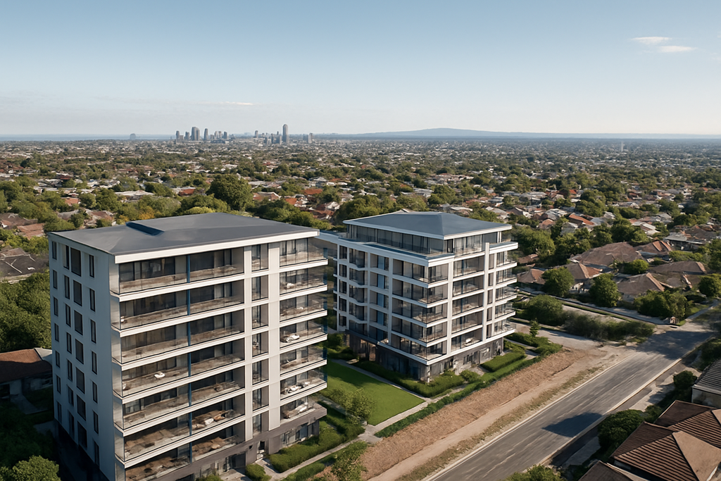
Drone services for construction companies, builders and property developers, including site flyovers, progress photography, videography, mapping, inspections, level views and development visualisation.

RLs and Level Views Melbourne for property developers and architects
Flying Glass provides specialist RLs and level views Melbourne services for property developers, architects, rendering companies, planners and development marketing teams across Victoria. Using professional drone platforms, we can position a camera at nominated elevations to capture the future outlook from proposed apartments, commercial buildings and other developments before construction is complete. Our RLs and level views Melbourne work is designed around the requirements of the development team. That may mean capturing views from multiple proposed floor levels, producing panoramas from specific locations, supplying clean background imagery for architectural renders or documenting surrounding landmarks, city views and future outlook for sales and marketing material. Flying Glass has extensive experience working with property developers, architects and visualisation teams and understands that accurate positioning, consistent framing and clear communication are critical when the imagery will feed into a larger development or rendering workflow. For broader Melbourne commercial capability, see our drones Melbourne page.

Need Future Views or RL Photography for a Melbourne Development?

Send Flying Glass the site address, nominated RLs or heights, proposed camera locations and required outputs. We can review the brief and recommend a capture plan for the project.

Discuss Your Melbourne Development

Professional RLs and Level Views Melbourne

RLs and level views Melbourne services allow project teams to see and communicate what the outlook from a proposed building may look like before that building exists.

The drone can be positioned at agreed locations and elevations to capture imagery from proposed:

  • Apartment levels
  • Penthouse levels
  • Balconies
  • Rooftop terraces
  • Commercial floors
  • Podium levels
  • Common areas
  • Future viewing positions

These images can then be used by developers, architects, rendering companies and marketing teams for a wide variety of planning and presentation purposes.

For our national capability, see our dedicated drone RLs and level views service.

RLs and level views Melbourne for property developers, architects and rendering companies, including future views, construction progress and aerial context.

Future View Photography for Melbourne Property Developments

Future-view photography is one of the most valuable applications of RLs and level views Melbourne capture.

A development may be months or years from completion, but prospective buyers and project stakeholders still want to understand what the outlook may be from a particular level.

Drone imagery can help communicate:

  • City skyline views
  • Water views
  • Park and open-space outlook
  • Mountain or regional views
  • Nearby landmarks
  • Street orientation
  • Neighbouring buildings
  • Future apartment outlook
  • Sunset or daylight perspectives

The capture plan can be developed around nominated floor levels and camera positions supplied by the project team.

RL Photography for Property Developers

Property developers are one of the main clients for our RLs and level views Melbourne work.

We can support developments during:

  • Site acquisition
  • Design development
  • Planning
  • Pre-sales
  • Marketing
  • Construction
  • Completion

Depending on the project, a single site visit may capture several different future-view positions and elevations so the resulting dataset can support both technical and marketing requirements.

For broader developer services, see our drone services for property developers.

Working With Architects and Design Teams

Architects may use RLs and level views Melbourne imagery to understand the relationship between a proposed building and the surrounding environment.

Drone capture can provide useful visual context around:

  • Building orientation
  • View corridors
  • Surrounding development
  • Landscape context
  • Nearby infrastructure
  • Urban form
  • Site relationships

Where a project requires several viewpoints, Flying Glass can work from architectural plans, nominated coordinates or diagrams supplied by the project team.

Drone Imagery for Rendering Companies

Flying Glass regularly works with rendering and architectural-visualisation teams that require accurate real-world imagery for proposed developments.

RLs and level views Melbourne capture can provide real photographic backgrounds that help rendering companies place a proposed development into its actual surroundings.

Depending on the rendering workflow, we can capture:

  • Background panoramas
  • Future-view images
  • Context photographs
  • Multiple elevations
  • Multiple orientations
  • Clean horizon imagery
  • City or landscape context

The required camera position, height, orientation and lens should ideally be agreed before flying so the source material matches the intended render as closely as possible.

For this application, see our dedicated drone renders service.

How RL and Level-View Drone Capture Works

A typical RLs and level views Melbourne project starts with the development team providing the site and required elevations.

Useful information may include:

  • Site address
  • Coordinates
  • Required RLs
  • Floor levels
  • Camera positions
  • Direction of view
  • Lens requirements
  • Reference plans
  • Render requirements
  • Preferred time of day

Flying Glass then reviews the location, airspace and operational environment before planning the flight.

During capture, the aircraft is positioned at the required location and altitude and the imagery is recorded according to the agreed brief.

Multiple RLs and Floor Levels

Many developments require imagery from more than one proposed floor.

A single RLs and level views Melbourne flight may therefore capture several nominated elevations, for example:

  • Level 3
  • Level 5
  • Level 10
  • Level 15
  • Penthouse level
  • Rooftop terrace

The exact heights should be supplied by the client or project consultant so the aerial capture reflects the required reference levels.

Where multiple orientations are needed, the drone can also capture north, south, east and west views or specific directions nominated by the design team.

Panoramas and Wide Future Views

Panoramic imagery can be particularly useful for RLs and level views Melbourne projects because it gives the visualisation or marketing team much greater flexibility than a single narrow photograph.

Panoramas may be used for:

  • Architectural visualisation
  • Interactive sales displays
  • Future-view marketing
  • Project presentations
  • Render backgrounds
  • View analysis

The appropriate capture format should be agreed before the flight based on the intended final output.

RLs, Level Views and Development Marketing

Future views can become powerful marketing assets when they are captured professionally and used accurately.

For development marketing teams, RLs and level views Melbourne imagery can help communicate the relationship between the project and its surroundings well before buyers can physically visit an upper floor.

Potential uses include:

  • Display-suite presentations
  • Sales brochures
  • Project websites
  • Advertising campaigns
  • Interactive view selectors
  • Architectural renders
  • Investor presentations

Flying Glass can also capture polished aerial photography and video of the surrounding area to complement the technical future-view imagery.

Drone Photography for Melbourne Property Developers

Beyond RLs and level views Melbourne, Flying Glass can provide a broader aerial-content package for property-development clients.

This may include:

  • Site photography
  • Surrounding-location imagery
  • Aerial neighbourhood context
  • Marketing stills
  • Aerial video
  • Construction progress capture
  • Milestone filming
  • Completed-development imagery

This allows a developer to work with one aerial provider across several stages of the project rather than treating every requirement as a separate supplier engagement.

Construction Progress Photography Melbourne

Once construction begins, Flying Glass can continue supporting the same development with recurring aerial photography.

Construction progress capture can document:

  • Site establishment
  • Excavation
  • Structural progress
  • Facade installation
  • Roof completion
  • Landscaping
  • Major milestones
  • Final completion

Recurring imagery can be useful for developers, builders, consultants, investors and stakeholders who need a clear visual record of progress.

For broader construction support, see our construction drone services.

Construction Drone Videography Melbourne

Video can complement progress photography by showing movement, scale and the relationship between different parts of a project.

Flying Glass can provide:

  • Milestone videos
  • Project progress updates
  • Stakeholder content
  • Marketing videos
  • Completion films
  • Aerial construction sequences

For polished project video, see our construction drone videography service.

Drone Mapping for Melbourne Developments

Some development projects require systematic aerial capture in addition to visual photography.

Flying Glass can provide mapping and photogrammetry for suitable sites where the client needs more structured aerial data.

Potential outputs may include:

  • Orthomosaics
  • 3D models
  • Point clouds
  • Site context
  • Repeat aerial datasets

Where mapping is required alongside RLs and level views Melbourne, the two workflows can potentially be coordinated within a broader site-capture program.

See our drone mapping services and drone photogrammetry services.

Melbourne Development Sites and Complex Locations

Some of the most valuable development sites are also located in complex environments.

CBD and metropolitan RLs and level views Melbourne projects may involve:

  • Controlled airspace
  • Nearby heliports
  • Roads
  • Pedestrians
  • Buildings
  • Restricted launch areas
  • Private property
  • Construction activity
  • High-rise environments

Flying Glass assesses each proposed operation individually before confirming the capture plan.

RLs and Level Views in Melbourne CBD

Melbourne CBD developments can offer some of the most commercially valuable future-view imagery, but they can also require more operational planning.

RLs and level views Melbourne in dense urban areas may require careful consideration of:

  • Launch position
  • Airspace
  • Building proximity
  • Roads
  • People
  • Required height
  • Flight path
  • Property permissions

Sending us the proposed location and RLs early allows our team to assess feasibility before the imagery is committed to a marketing or visualisation schedule.

Why Choose Flying Glass for RLs and Level Views Melbourne?

Flying Glass has extensive experience working with property-development teams and understands that RLs and level views Melbourne imagery must be both technically useful and visually strong.

  • Experience with property developers
  • Experience with architects and design teams
  • Experience with rendering companies
  • Accurate nominated-height capture
  • Multiple RL and floor-level capability
  • Panoramic future-view imagery
  • Professional aerial photography
  • Construction progress capability
  • Drone mapping and photogrammetry
  • Melbourne-based crews
  • Professional CASA planning
  • National Flying Glass support

Local Melbourne Crews for Property Development Projects

Flying Glass has local Melbourne crews available for development and construction work throughout Victoria.

For recurring RLs and level views Melbourne or construction projects, local capability can provide practical advantages including:

  • Efficient mobilisation
  • Weather flexibility
  • Repeat site visits
  • Progress capture
  • Consistent imagery
  • Coordination with architects and project teams

The Melbourne team can also draw on Flying Glass’s wider national equipment and specialist crew network where additional capability is required.

Areas We Service Across Melbourne and Victoria

Flying Glass provides RLs and level views Melbourne services across metropolitan Melbourne and regional Victoria.

Projects may include:

  • Melbourne CBD
  • Inner Melbourne
  • Eastern suburbs
  • Western suburbs
  • Northern suburbs
  • South-eastern Melbourne
  • Bayside
  • Mornington Peninsula
  • Geelong
  • Regional Victorian developments

Every site is assessed according to its specific airspace, surroundings, required heights and intended flight.

Planning an RL or Level-View Drone Shoot

For the fastest assessment of an RLs and level views Melbourne project, send us:

  • Site address
  • Required RLs or heights
  • Proposed camera positions
  • Direction of view
  • Architectural plans if available
  • Render brief if applicable
  • Preferred lens or field of view
  • Required image format
  • Preferred date and time
  • Any known site access requirements

If you are working with a rendering or visualisation company, we are also happy to liaise directly with their team to clarify the capture requirements.

Frequently Asked Questions About RLs and Level Views Melbourne

What are RLs and level views?

RLs and level views Melbourne capture uses a drone to photograph the outlook from nominated elevations and locations, often corresponding to proposed floors or viewing positions within a future development.

Can you capture views from several proposed floors?

Yes. A single flight can potentially capture multiple nominated RLs or floor heights, subject to the location and operational environment.

Do you work with property developers?

Yes. Flying Glass works with developers on future-view photography, RLs, render imagery, development marketing, construction progress and other aerial requirements.

Do you work with architects?

Yes. We can work from architectural plans, nominated positions and required elevations to capture imagery supporting design, presentation and visualisation.

Can you work directly with rendering companies?

Yes. Flying Glass can liaise with rendering and visualisation teams to understand camera position, orientation, lens and background-image requirements before capture.

Can you provide panorama images?

Yes, where required. Panoramas can be particularly useful for future-view presentations, renders and interactive development marketing.

Can you provide construction progress photography as well?

Yes. Flying Glass can continue supporting the development after the initial RLs and level views Melbourne capture with recurring progress photography, video and other aerial documentation.

Can you capture imagery for architectural renders?

Yes. We provide aerial context and background imagery specifically for integration into development renders and visualisation workflows.

Can you provide drone mapping?

Yes, for suitable projects. Drone mapping and photogrammetry can be provided where the development team requires systematic aerial datasets in addition to visual photography.

Can you capture level views in Melbourne CBD?

Potentially. CBD operations need to be assessed for airspace, building proximity, roads, people, launch areas and the required height. Send us the site and RLs so we can assess feasibility.

How much do RLs and level views Melbourne services cost?

Pricing depends on the number of RLs, camera positions, required outputs, site complexity, travel, approvals and whether additional photography or construction services are required. Send us the brief for a tailored quote.

Book RLs and Level Views in Melbourne

If your development requires professional RLs and level views Melbourne imagery, send Flying Glass the site, proposed heights and required viewing positions.

Our Melbourne team can work with developers, architects, rendering companies and marketing teams to capture future views, render backgrounds, development imagery and construction content throughout Victoria.

Contact Flying Glass about your Melbourne property-development project.

Construction drone videography across Australia for project progress, milestones, stakeholder updates and completed developments.

Construction projects change quickly. A site that is open ground today may contain structures, roads, services and completed buildings only months later. Professional construction drone videography creates a visual record of that transformation while also giving project teams, developers and stakeholders an engaging way to understand progress from above.

Flying Glass provides construction drone videography across Australia for builders, developers, principal contractors, project managers, architects, engineers and property organisations. We can capture one-off project milestones or return throughout the construction lifecycle to build a consistent visual history of the site.

Our aerial crews can document earthworks, structural progress, major installations, construction activity, project milestones and completed developments using professional cinema drones and repeatable filming approaches.

This service forms part of our broader construction drone services, which combine aerial video with photography, mapping, level views, development visualisation and other specialist capture for construction and property projects.

Need Ongoing Video of a Construction Project?

Send Flying Glass the site location, project timeline, required filming frequency and intended audience. We can design a construction drone videography program around the important stages of the build rather than simply capturing unrelated footage on each visit.
Discuss Your Construction Project

Construction drone videography across Australia for project progress, milestones, stakeholder updates and completed developments.

Professional Construction Drone Videography

Construction drone videography gives project teams a perspective that is difficult to achieve from ground level. Aerial video can show the entire site, relationships between different work areas and the scale of progress occurring across a development.

Flying Glass can film:

  • Site establishment
  • Demolition and early works
  • Earthworks
  • Excavation
  • Foundations
  • Structural construction
  • Facade installation
  • Roof works
  • Roads and access
  • Major plant and equipment
  • Services and infrastructure
  • Landscape works
  • Project milestones
  • Practical completion
  • Finished developments

The footage can be captured as a straightforward visual record or planned more creatively for project films, stakeholder communications and marketing.

Construction Progress Videography

One of the strongest uses of construction drone videography is documenting progress over time.

Rather than relying on occasional phone photos or inconsistent aerial images, scheduled drone filming creates a professional record of how the project develops from one stage to the next.

Progress filming can help communicate:

  • Overall site development
  • Completion of major work packages
  • Structural progress
  • Changes in access and logistics
  • Installation of significant assets
  • External works
  • Development of surrounding infrastructure
  • Transition from construction site to completed project

For long-running projects, Flying Glass can establish a repeatable construction drone videography approach so key views, flight paths and framing remain recognisable between visits.

Monthly and Recurring Construction Drone Video

Many construction projects benefit from scheduled aerial capture rather than waiting until somebody remembers that updated footage is needed.

Recurring construction drone videography can be organised monthly, at defined project stages or around major milestones.

The appropriate frequency depends on the pace of the project. A rapidly changing civil or structural phase may justify regular capture, while other projects may benefit more from filming at key moments such as:

  • Site commencement
  • Completion of bulk earthworks
  • Structure topping out
  • Facade completion
  • Major equipment installation
  • Landscaping
  • Practical completion
  • Final marketing capture

Planning those points early ensures the most important stages are not missed.

Construction Drone Videography for Developers

Property developers use aerial video for much more than construction documentation.

Construction drone videography can help developers communicate progress to investors, purchasers, joint-venture partners, internal teams and other stakeholders who may not regularly visit the site.

Video can show:

  • The overall development footprint
  • Relationship to surrounding areas
  • Progress of individual buildings
  • Road and infrastructure works
  • Views and location context
  • Major construction milestones
  • The evolution of the project over time

Flying Glass also provides broader drone services for property developers, including level views, renders, progress capture, mapping and completed-project imagery. We offer this in and around Sydney and nationwide.

For Melbourne developments requiring imagery before or alongside construction filming, Flying Glass also provides RLs and level views Melbourne capture for future outlooks, renders and development marketing.

Construction Video for Stakeholder Updates

Large construction projects often involve stakeholders who are spread across different offices, cities or countries.

A well-filmed aerial update can communicate the status of a project much faster than a long series of static photographs.

Construction drone videography may be incorporated into:

  • Board presentations
  • Investor updates
  • Client reporting
  • Project newsletters
  • Internal communications
  • Government or council updates
  • Community engagement
  • Contractor communications
  • Social media
  • Corporate presentations

The footage can be supplied as high-quality raw material for an existing production team or incorporated into a broader edited project video where required.

Construction Marketing and Development Video

Not all construction imagery is purely documentary. As a development becomes recognisable, the same site may become part of the project’s marketing story.

Professional construction drone videography can capture the scale of the project, its setting and the transformation taking place around it.

This may be useful for:

  • Development marketing
  • Corporate brand films
  • Project launch content
  • Leasing campaigns
  • Investor communications
  • Award submissions
  • Contractor capability videos
  • Project completion films
  • Social and digital campaigns

Where marketing begins before construction is complete, aerial video can also work alongside drone RLs and level views and drone renders to help communicate what the finished development will look like.

Construction Site Drone Flyovers

A structured aerial flyover can form one component of construction drone videography.

Flyovers are particularly useful when stakeholders need a clear overview of the entire site rather than a heavily edited promotional sequence.

Flying Glass also provides dedicated construction site drone flyovers for projects requiring consistent aerial overviews, progress documentation and repeatable site coverage.

The two services can complement one another: a project may use structured flyovers for recurring documentation and more cinematic filming at major milestones or completion.

Consistent Camera Positions and Flight Paths

Repeatability is particularly valuable when construction drone videography is being used to show change over time.

Where practical, Flying Glass can establish consistent:

  • Flight directions
  • Site approaches
  • Camera angles
  • Altitude ranges
  • Reveal shots
  • Orbit positions
  • Key project viewpoints

Exact repeatability will always depend on the changing construction environment, cranes, temporary structures, aviation constraints and weather, but consistent planning makes progress comparisons far more effective.

Construction Drone Video and Aerial Photography

Video and photography serve different purposes, and many projects benefit from collecting both during the same site visit.

Construction drone videography is particularly effective for showing movement, scale and relationships across the site. High-resolution still photography is useful for reports, presentations, web content, records and detailed visual comparison.

Combining both can give project teams:

  • Cinematic progress footage
  • High-resolution site photographs
  • Marketing imagery
  • Stakeholder presentation material
  • Consistent visual records

This approach can make each site visit more valuable without requiring separate aerial mobilisation for video and still photography.

Drone Mapping Alongside Construction Videography

Some projects need both visual storytelling and measurable aerial data.

In those cases, construction drone videography can be delivered alongside mapping or reality-capture services where the operating environment and project requirements allow.

Flying Glass provides professional drone mapping services and drone photogrammetry services for projects requiring orthomosaics, point clouds, 3D models, volume information and other spatial outputs.

The capture requirements for cinematic video and photogrammetry are different, so the flight plan needs to account for each deliverable rather than assuming footage collected for one purpose can automatically produce the other.

Construction Videography for Major Infrastructure Projects

Construction drone videography is equally useful beyond building developments.

Flying Glass can support construction and progress filming around:

  • Road projects
  • Rail infrastructure
  • Bridges
  • Renewable-energy projects
  • Industrial facilities
  • Utilities
  • Major civil works
  • Transport infrastructure
  • Remote construction sites

Our broader infrastructure drone services can combine visual documentation with inspections, mapping and specialist aerial operations across the asset lifecycle.

Construction Drone Videography for Completed Projects

Completion is often the point when the visual value of a construction project is highest.

After months or years of documenting progress, final construction drone videography can capture the finished development without temporary works, heavy construction activity and incomplete landscaping dominating the image.

Completed-project filming may be used by:

  • Developers
  • Builders
  • Architects
  • Engineering firms
  • Contractors
  • Property marketing teams
  • Asset owners

Final footage can show the development in its broader context and provide polished material for company websites, case studies, award entries, tenders and future marketing.

Professional Equipment for Construction Drone Video

The required aircraft depends on the site, deliverables and filming environment.

Flying Glass operates professional drone systems suitable for both efficient site documentation and high-end cinematic capture.

Depending on the project, our construction drone videography capability can include:

  • Professional cinema drones
  • High-resolution video capture
  • Multiple lens options
  • Dual-operator camera workflows
  • Compact aircraft for suitable environments
  • FPV capability where relevant
  • Director and client monitoring
  • Backup aircraft and critical equipment

The goal is to match the equipment to the site and final use of the footage rather than use the largest or most complicated aircraft unnecessarily.

Working Safely on Active Construction Sites

Active sites introduce hazards that need to be considered before aerial operations begin.

Professional construction drone videography may require coordination around:

  • Cranes
  • Temporary structures
  • Mobile plant
  • Workers
  • Vehicle movements
  • Exclusion zones
  • Site inductions
  • Restricted access
  • Nearby airspace
  • Public interfaces

Flying Glass works with site management and production teams to establish an appropriate operating area and flight plan around the work taking place on the day.

Construction Drone Videography Across Australia

Flying Glass provides construction drone videography across metropolitan, regional and remote Australia.

We can support construction projects throughout:

  • New South Wales
  • Victoria
  • Queensland
  • Western Australia
  • South Australia
  • Tasmania
  • Australian Capital Territory
  • Northern Territory
  • Regional and remote project locations

For major multi-site programs, Flying Glass can also coordinate consistent aerial capture across geographically distributed projects and draw on an established network of experienced drone professionals where appropriate.

Why Choose Flying Glass for Construction Drone Videography?

Effective construction drone videography requires both professional aerial filming capability and the ability to work reliably around active commercial projects.

  • Experienced professional drone crews for complex commercial environments
  • High-end filming capability for both progress documentation and polished marketing footage
  • Construction and development experience across multiple aerial services
  • Repeatable progress capture for long-running projects
  • Photography and video capability within the same site visit
  • Mapping and photogrammetry capability where projects also require spatial outputs
  • Advanced aviation experience for complex locations
  • Australia-wide operations including regional and remote projects
  • Multi-site capability for larger programs of work
  • Professional equipment redundancy for important project milestones

Frequently Asked Questions About Construction Drone Videography

How often should we film a construction project?

The ideal frequency depends on the project. Construction drone videography may be scheduled monthly, at major milestones or more frequently during periods of rapid change. We can help determine a useful capture schedule around the construction program.

Can you film the same views each month?

Yes, where site and operating conditions allow. We can establish repeatable flight paths and key viewpoints so footage from different stages of the project is easier to compare.

Can you provide both video and still photography?

Yes. Many construction clients capture professional aerial video and high-resolution still photography during the same site visit.

Can you create progress videos for stakeholders?

Yes. Construction drone videography can be used for investor updates, board presentations, project communications, internal reporting and other stakeholder content.

Can you film a completed development for marketing?

Yes. We can capture polished final aerial footage for developers, builders, architects and other project partners to use in marketing, case studies, tenders and award submissions.

Is a construction flyover the same as construction videography?

Not exactly. A construction flyover is usually a structured aerial overview of a site. Construction drone videography is broader and may include cinematic progress footage, milestone sequences, marketing content, stakeholder updates and completed-project filming.

Can you provide mapping as well as video?

Yes. Flying Glass can provide mapping, photogrammetry and other aerial data services alongside construction video where required. Each deliverable is planned using an appropriate capture methodology.

Do you provide construction drone videography outside Sydney?

Yes. Flying Glass provides construction drone videography throughout Australia, including metropolitan, regional and remote construction sites.

Discuss Your Construction Video Requirements

If your project requires professional construction drone videography, send Flying Glass the site location, construction program, filming frequency and required outputs.

We can design a capture program around major milestones, ongoing progress reporting or a finished-project marketing brief and help ensure the aerial footage remains useful throughout the life of the project.

Whether you need monthly progress footage, a major milestone captured, stakeholder communications or a polished final project film, Flying Glass can provide the aerial expertise and professional production quality required.

Contact Flying Glass to discuss construction drone videography for your project.

DJI Inspire 3 capturing professional construction drone services over a major commercial building site in Australia at sunrise

Construction projects generate an enormous amount of information.

Developers need to keep investors informed. Builders need to demonstrate progress. Project managers need clear visual records. Marketing teams require professional imagery, while stakeholders often want to understand the overall development without visiting the site.

Professional construction drone services provide an efficient way to capture that information from perspectives that simply cannot be achieved from the ground.

Whether documenting a major commercial development, photographing a residential subdivision or producing marketing material for a completed project, aerial imagery helps communicate scale, progress and quality with remarkable clarity.

At Flying Glass, we work with developers, builders, consultants, government agencies and infrastructure organisations across Australia to deliver high-quality aerial photography and video throughout every stage of the construction lifecycle.

Our work combines commercial photography, cinematic aerial filming and extensive aviation experience, allowing us to safely capture imagery in some of Australia’s most challenging construction environments.

Construction Drone Services Demand Professional Aviation Experience

Active construction sites are constantly changing. Tower cranes move throughout the day, workers and subcontractors operate across multiple work areas, deliveries arrive continuously and site layouts evolve as the project progresses.

Flying Glass approaches every construction project as a professional aviation operation rather than simply a photography assignment.

We hold a CASA Operations Over or Near People (OONP) Instrument, allowing us to conduct eligible operations over or near people in accordance with the instrument and our approved procedures.

Combined with approved parachute recovery systems on suitable aircraft and extensive experience operating in complex commercial environments, our construction drone services give developers and builders confidence that their aerial imagery is being captured safely, professionally and legally.

Why Construction Companies Are Investing in Drone Services

Construction is no longer documented solely through site diaries and ground-level photography.

Today’s projects involve numerous stakeholders, including developers, investors, consultants, financiers, councils, builders and future tenants. Each group requires accurate, engaging and up-to-date information about how a project is progressing.

Professional construction drone services provide that information quickly and efficiently.

Rather than relying on dozens of disconnected ground photographs, a single aerial image can communicate the overall state of a project in seconds.

Drone photography also provides valuable context by showing how the development sits within the surrounding suburb, transport network, neighbouring buildings and broader landscape.

This wider perspective helps stakeholders understand not only what has been built, but how the project is taking shape within its environment.

Construction site drone flyovers are commonly used for:

  • Progress monitoring.
  • Stakeholder reporting.
  • Developer marketing.
  • Investor communications.
  • Project documentation.
  • Tender submissions.
  • Website and social media content.
  • Completion photography.
  • Corporate reporting.
  • Historical project records.

By capturing consistent, high-quality aerial imagery throughout the project, construction teams create a valuable visual record that can continue delivering value long after practical completion.

DJI Inspire 3 capturing professional construction drone services over a major commercial building site in Australia at sunrise

Construction Drone Services for Progress Monitoring

Progress monitoring is one of the most valuable applications for professional construction drone services.

Our construction drone services allow project teams to document how a site changes over time using consistent viewpoints that clearly demonstrate each stage of the build.

Developers and builders often schedule photography at key milestones, while larger projects may benefit from monthly or even fortnightly updates.

These repeat visits create a chronological visual record that supports both project management and stakeholder communication.

Because the camera positions remain consistent, comparisons between different dates become straightforward, allowing project teams to quickly identify how the development is progressing.

Progress monitoring is commonly used for:

  • Monthly project updates.
  • Executive reporting.
  • Board presentations.
  • Investor reporting.
  • Client updates.
  • Internal project reviews.
  • Marketing milestones.
  • Completion documentation.

Unlike ground photography, aerial imagery provides a complete overview of the project, helping stakeholders immediately understand the relationship between completed works, active work areas and future stages.

Flying Glass also supports the construction and ongoing monitoring of solar, wind and energy infrastructure through our specialist renewable energy drone services.

Industry Insight

The most valuable progress photography isn’t created by flying wherever looks interesting each month. It comes from carefully repeating the same camera positions throughout the life of the project. This consistency allows stakeholders to compare progress quickly and creates a professional visual record that becomes increasingly valuable as construction advances.

Keeping Stakeholders Informed

Large construction projects involve people who may rarely visit the site.

Developers may be based interstate. Investors may only receive monthly reports. Consultants often work across multiple projects, while executive teams need concise updates that communicate progress without requiring lengthy site inspections.

Professional construction drone services help bridge that gap by giving stakeholders a clear and current overview of the project.

A well-composed image can communicate weeks of progress in a single glance, making reports easier to understand and significantly more engaging.

Construction drone imagery is regularly incorporated into:

  • Monthly reports.
  • Investor presentations.
  • Board papers.
  • Client updates.
  • Government reporting.
  • Project newsletters.
  • Community engagement.
  • Corporate communications.

By combining wide establishing photographs with closer detail images, project teams can communicate both the overall scale of the development and the specific milestones achieved during each reporting period.

This visual approach often improves engagement because stakeholders spend less time interpreting written descriptions and more time understanding the project itself.

Marketing Developments Before They’re Finished

Construction projects often begin attracting buyers, tenants or investors long before the final crane leaves site.

Professional construction drone services provide developers with powerful photography and video throughout the life of a project, helping demonstrate progress while building confidence in the finished development.

Rather than relying solely on artist impressions, aerial photography shows genuine progress and provides valuable context for prospective purchasers.

Images captured during construction can be used across:

  • Project websites.
  • Sales campaigns.
  • Leasing brochures.
  • Investor updates.
  • Social media.
  • Email marketing.
  • Media releases.
  • Development signage.

As the project approaches completion, aerial imagery becomes even more valuable by showcasing landscaping, surrounding amenities, transport connections and the relationship between the completed development and its wider environment.

These images often continue being used for years after practical completion, making professional photography a worthwhile long-term investment.

For development teams requiring aerial support across the entire project lifecycle, our drone services for property developers bring together planning imagery, construction progress and final marketing content. Before construction begins, we can also capture accurate RLs and level views and provide aerial imagery for drone renders that show proposed developments within their real-world surroundings.

As well as a Sydney-based crew, we also have a Melbourne-based crew, who can support developments from early future-view capture through construction, including specialist RLs and level views Melbourne services for proposed floors, renders and development marketing.

Supporting Builders and Principal Contractors

Builders face constant pressure to deliver projects safely, efficiently and on schedule.

Professional construction drone services provide another tool that can assist with communication, documentation and project management.

Regular aerial imagery allows site teams to review progress from perspectives that are difficult to achieve on foot.

Wide aerial views help illustrate:

  • Overall site layout.
  • Access routes.
  • Crane locations.
  • Material storage areas.
  • Completed works.
  • Future work zones.
  • Temporary facilities.
  • Project staging.

Because construction sites evolve so quickly, maintaining a consistent visual record can simplify project reviews and provide valuable reference material throughout the build.

Many principal contractors also use aerial imagery for capability statements, award submissions and future tender opportunities, demonstrating their ability to successfully deliver major projects.

Industry Insight

Some of the most valuable aerial photographs are captured immediately before significant project milestones, such as topping out, façade completion or practical completion. These moments often become the images that appear in annual reports, award submissions and future marketing campaigns.

Supporting Architects, Engineers and Consultants

Construction projects rely on collaboration between numerous specialist consultants.

Architects, engineers, project managers, planners and asset owners all require clear visual information throughout different phases of a development.

Professional construction drone services provide a common visual reference that supports communication across multiple disciplines.

For example, aerial imagery can help consultants understand:

  • Overall site context.
  • Relationships between structures.
  • Site access arrangements.
  • Construction sequencing.
  • Surrounding developments.
  • Landscape integration.
  • Neighbouring infrastructure.
  • Project interfaces.

While aerial photography does not replace engineering inspections or specialist surveying, it provides an invaluable visual overview that often improves communication between project teams.

Commercial, Civil and Infrastructure Projects

Flying Glass supports far more than traditional building construction.

Professional construction drone services are equally valuable across large infrastructure, transport and industrial developments.

Typical projects include:

  • Road upgrades.
  • Rail infrastructure.
  • Industrial facilities.
  • Warehouses and logistics centres.
  • Renewable energy projects.
  • Ports and marine infrastructure.
  • Water infrastructure.
  • Government developments.
  • Major subdivisions.
  • Commercial precincts.

These projects often extend across large geographic areas, making aerial photography one of the most effective ways to communicate progress.

A single image may capture kilometres of completed work that would otherwise require dozens of ground photographs to document.

For clients managing multiple contractors and stakeholders, this broader perspective often makes project reporting significantly easier.

Professional construction drone videography can document a project from early works through to practical completion, creating consistent progress footage for stakeholders alongside polished aerial video for marketing, case studies and completed-project promotion.

Construction Drone Video

While construction drone services often begin with progress photography, professional video adds another dimension by showing how a project fits within its surrounding environment.

Professional construction drone videography can reveal the scale of a development, demonstrate access routes and showcase completed works through smooth cinematic movement.

Construction video is commonly used for:

  • Project launches.
  • Marketing campaigns.
  • Investor presentations.
  • Corporate communications.
  • Completion videos.
  • Social media.
  • Award submissions.
  • Client handovers.

Flying Glass combines traditional aerial cinematography with FPV capability where appropriate, allowing developers and builders to create engaging promotional content that goes well beyond standard progress documentation.

A completed commercial precinct, for example, may be introduced with sweeping cinematic aerial footage before transitioning into an immersive FPV sequence that moves naturally through streets, landscaped areas and public spaces.

This combination provides developers with compelling marketing content that helps future buyers and tenants experience the development long before they arrive on site.

Building Long-Term Visual Records

One of the greatest strengths of professional construction drone services is consistency.

Rather than treating each visit as an isolated photography assignment, Flying Glass works with many clients throughout the life of a project.

By carefully repeating camera positions and maintaining consistent photographic standards, we create a chronological visual record that documents the entire construction journey.

This ongoing relationship delivers benefits well beyond project completion.

The resulting image library becomes a valuable resource for future marketing, capability statements, media enquiries, recruitment campaigns, investor reporting and historical documentation.

Years after the project has finished, these photographs continue telling the story of how the development came together.

Operating Safely on Active Construction Sites

Construction sites present some of the most dynamic operating environments for commercial drone operations.

Unlike many other filming locations, the site can change daily. Tower cranes rotate, new structures are erected, delivery vehicles arrive, subcontractors move throughout the project and work areas continually evolve.

Professional construction drone services require considerably more than simply arriving with a drone and taking photographs.

Every operation begins with detailed planning to ensure aerial imagery can be captured safely while working around the unique conditions of an active construction site.

Depending on the project, this may include:

  • Site inductions.
  • Coordination with the principal contractor.
  • Review of site-specific safety requirements.
  • Assessment of crane operations.
  • Identification of exclusion zones.
  • Weather and wind assessments.
  • Airspace planning.
  • Selection of the most appropriate aircraft.
  • Communication with site supervisors.
  • Planning around deliveries and high-risk activities.

By integrating with the construction team’s existing planning processes, aerial photography can often be completed efficiently while minimising disruption to site operations.

Professional Approvals for Complex Construction Projects

Many commercial construction sites remain active while aerial photography is being undertaken. Workers continue their activities, deliveries arrive, neighbouring businesses remain occupied and public areas often surround the development.

Flying Glass holds a CASA Operations Over or Near People (OONP) Instrument, allowing us to conduct eligible operations over or near people in accordance with the instrument and our approved procedures.

We have also invested in approved parachute recovery systems on suitable aircraft, providing additional risk mitigation where appropriate for complex commercial operations.

Flying Glass has contributed to CASA’s Technical Working Group relating to Operations Over or Near People, reflecting our commitment to advancing safe and practical drone operations across Australia.

For developers, builders and project managers, this means working with a team that understands not only how to create exceptional imagery, but also how to safely and legally operate in challenging commercial environments.

Consistency Creates Long-Term Value

One of the greatest advantages of engaging the same drone operator throughout a construction project is consistency.

Rather than producing a collection of unrelated photographs, Flying Glass carefully repeats camera positions across each visit wherever practical.

This creates a consistent visual timeline that allows project teams to compare genuine progress between reporting periods.

Over the life of a project, these images become a valuable historical record that can support:

  • Board reporting.
  • Investor presentations.
  • Marketing campaigns.
  • Award submissions.
  • Capability statements.
  • Recruitment campaigns.
  • Media enquiries.
  • Project archives.

Many clients continue using these photographs long after construction has finished because they provide an authentic record of how the development came together.

Why Image Quality Matters

Construction projects often represent investments worth tens or hundreds of millions of dollars.

The photography and video delivered through professional construction drone services should reflect that level of investment and quality.

Professional construction drone photography is about far more than flying above the site.

Light, weather, composition, camera position and timing all influence the final image.

For example, early morning light often creates stronger architectural definition and reduces harsh shadows, while carefully selected camera angles help communicate both the scale of the project and its relationship with surrounding infrastructure.

Flying Glass applies the same photographic principles used across television, advertising and commercial productions to every construction assignment.

The result is imagery that not only documents progress but also enhances the way the project is presented to clients, investors and the wider market.

Industry Insight

Some of the most valuable construction photographs are captured at sunrise or sunset rather than during the middle of the day. Better light creates stronger contrast, warmer colours and more three-dimensional images, making developments appear significantly more premium in marketing and stakeholder communications.

Why Developers and Builders Choose Our Construction Drone Services

Flying Glass combines extensive commercial aviation experience with high-end photography and cinematography.

Our team understands that construction clients are looking for more than attractive aerial images. They need reliable documentation, professional communication, consistent reporting and an operator capable of working safely within demanding commercial environments.

Clients choose Flying Glass because we provide:

  • More than 12 years of commercial drone operations.
  • More than 30 years of combined aviation experience.
  • Professional construction photography and videography.
  • Consistent progress monitoring throughout the life of a project.
  • Experience across commercial, residential and infrastructure developments.
  • A CASA Operations Over or Near People Instrument.
  • Approved parachute recovery systems on suitable aircraft.
  • Participation in CASA’s Technical Working Group relating to OONP.
  • Experience operating in controlled airspace and complex urban environments.
  • Nationwide availability throughout Australia.

Whether documenting a boutique residential development or a major infrastructure project, our objective remains the same: produce exceptional imagery while operating safely, professionally and efficiently.

For construction projects requiring detailed orthomosaics, point clouds, surface models or volumetric information, Flying Glass also provides drone photogrammetry services for repeatable site capture and reality mapping.

Choosing the Right Construction Drone Company

Not all drone operators have experience working on active construction sites.

While many businesses own professional drones, commercial construction projects require a combination of aviation knowledge, photographic skill and an understanding of how construction projects operate.

Before engaging a provider of construction drone services, consider asking the following questions:

  • Do they hold the appropriate CASA approvals and certifications?
  • Do they have experience working on active commercial construction sites?
  • Can they safely operate in controlled airspace if required?
  • Can they provide consistent repeat photography throughout the project?
  • Do they understand stakeholder reporting requirements?
  • Can they capture both photography and cinematic video?
  • Do they have experience working alongside builders, developers and principal contractors?
  • Can they coordinate with site management to minimise disruption?

The answers to these questions can have a significant impact on both the quality of the imagery and the efficiency of the overall project.

Construction Drone Services Australia

Flying Glass provides professional construction drone services throughout Australia for developers, builders, government agencies, consultants and infrastructure organisations.

Our services include:

  • Construction progress photography.
  • Construction drone videography.
  • Commercial development photography.
  • Residential development photography.
  • Industrial project documentation.
  • Infrastructure project imagery.
  • Completion photography.
  • Marketing photography.
  • Cinematic aerial video.
  • FPV drone filming where appropriate.

From early site establishment through to project completion, we work alongside project teams to create imagery that informs stakeholders, supports marketing and documents every stage of construction.

Why Flying Glass?

Flying Glass is trusted by organisations across Australia because we combine professional aviation capability with high-end commercial photography.

Our experience extends across television productions, advertising campaigns, tourism, government projects, infrastructure, commercial property and large-scale construction.

That diverse background means we understand how to create imagery that is not only technically excellent but also visually engaging and commercially valuable.

We recognise that every construction project is different.

Some clients require simple monthly progress photography, while others need a complete visual content library including photography, cinematic video and FPV footage for ongoing marketing campaigns.

Our approach is always tailored to the needs of the project, with an emphasis on safety, reliability and consistent quality.

Frequently Asked Questions

How often should construction drone photography be undertaken?

This depends on the project. Many commercial developments are photographed monthly, while fast-moving projects may benefit from fortnightly updates. Key construction milestones are also popular times to capture professional aerial imagery.

Can construction drone services be used on active construction sites?

Yes. Flying Glass regularly works on active commercial sites. Every operation is planned in consultation with the relevant project team and conducted in accordance with applicable CASA requirements and site safety procedures.

Can workers remain on site while drone operations are taking place?

Each operation is assessed individually. Depending on the circumstances, work may continue in accordance with the operational plan, the applicable approvals and the agreed site procedures.

Can you capture both photography and video?

Absolutely. Many clients request a combination of high-resolution aerial photography and cinematic drone video, allowing them to use the content across progress reporting, marketing campaigns, websites and social media.

Can you return to the same viewpoints each month?

Yes. Consistent repeat photography is one of the biggest advantages of working with the same professional drone operator throughout a project. Wherever practical, we replicate previous camera positions to create a clear visual timeline of construction progress.

Do you travel throughout Australia?

Yes. Flying Glass undertakes projects across Australia for developers, builders, government agencies, commercial organisations and infrastructure clients.

Partner With Flying Glass for Professional Construction Drone Services

Construction projects deserve imagery that reflects the scale, investment and expertise behind them.

Whether you require monthly progress photography, cinematic aerial video, marketing content for a new development or documentation of major infrastructure works, Flying Glass delivers professional construction drone services backed by extensive aviation experience and a commitment to safe, compliant operations.

From boutique developments through to nationally significant infrastructure projects, we help clients tell the story of construction with exceptional aerial photography and video that continues delivering value long after the project is complete.

Contact Flying Glass today to discuss professional construction drone services for your next project anywhere in Australia.

Drone services for property developers capturing aerial imagery of a large residential development under construction in Australia.

Successful property developments rely on clear communication, informed decision making and compelling marketing. From evaluating a potential site through to selling the final apartment or commercial tenancy, visual content plays a critical role in every stage of the development lifecycle.

Professional drone services for property developers provide far more than impressive aerial photographs. They enable developers to monitor progress, engage investors, support planning applications, market projects, document construction milestones and showcase completed developments from perspectives that simply cannot be achieved from the ground.

At Flying Glass, we work with developers, builders, architects, planners, project marketers and construction professionals across Australia, delivering high-quality aerial imagery and video tailored to the specific objectives of each project. Whether you’re planning a boutique residential development, a mixed-use precinct, an industrial estate or a large infrastructure project, our experienced team can capture the imagery you need safely, efficiently and professionally.

Every development tells a story. It begins with an empty block of land, evolves through planning and construction, and finishes as a thriving place where people live, work or visit. Our role is to help document that journey while producing imagery that supports commercial outcomes. This makes drone services for property developers valuable from the earliest feasibility stage through to project completion.

These services form part of Flying Glass’ broader construction drone services, supporting developers and project teams with aerial photography, video, progress monitoring and specialist visualisation services throughout the construction lifecycle.

Why More Developers Are Using Drone Services

Over the past decade, drones have become an invaluable tool for the property industry. What was once considered an exciting marketing extra has become an essential resource for planning, construction, investor communications and sales.

Professional drone services for property developers help teams make better decisions by providing accurate, up-to-date visual information throughout a project’s lifecycle.

Developers commonly use drone imagery to:

  • Assess potential development sites.
  • Monitor construction progress.
  • Produce investor updates.
  • Create marketing campaigns.
  • Support planning submissions.
  • Capture RLs and level views for proposed developments.
  • Record project milestones.
  • Capture completed developments.
  • Capture RLs (Level Views)
  • Showcase surrounding amenities.
  • Create social media and website content.

Unlike traditional photography, aerial imagery provides valuable context. It demonstrates how a site relates to surrounding roads, transport, neighbouring developments, green space, waterways and other key infrastructure.

This broader perspective helps stakeholders understand not only what is being built, but why the location itself adds value.

In addition to our Sydney based crew, for Victorian developments, our local team provides dedicated RLs and level views Melbourne capture for future outlooks, architectural renders, pre-sales marketing and nominated floor levels.

Drone services for property developers capturing aerial imagery of a large residential development under construction in Australia.

Supporting Developers From Site Acquisition

The earliest stages of a development are often the most important.

Before committing to a site, developers need as much information as possible to understand opportunities and constraints.

Aerial photography provides an immediate overview of:

  • Site boundaries.
  • Access roads.
  • Existing buildings.
  • Topography.
  • Vegetation.
  • Nearby infrastructure.
  • Neighbouring land uses.
  • Views and outlook.

Rather than relying solely on satellite imagery that may already be months or years old, developers can commission current drone services for property developers, obtaining aerial imagery that accurately reflects the site’s existing condition.

Having recent imagery also assists consultants working across planning, architecture, engineering and environmental assessments.

Helping Communicate Development Vision

Property development involves bringing together numerous stakeholders, each with different priorities and technical knowledge.

Professional aerial imagery helps communicate complex projects far more effectively than written reports alone. Used strategically, drone services for property developers can turn complex site information into clear visual material that is easier for stakeholders to understand.

Investors, financiers, councils, project partners and consultants can quickly understand a site’s context when presented with current aerial photography, video and drone renders that place proposed developments within their real-world surroundings.

This often leads to more productive discussions and faster decision making.

Many developers also use aerial imagery during planning and design workshops, helping architects and consultants visualise how proposed buildings will interact with the surrounding environment.

Drone Services During Planning and Development Approval

Obtaining planning approval often requires clear communication with multiple stakeholders.

Professional drone services for property developers provide current site imagery that can support planning documentation, community engagement and presentations to decision makers.

High-resolution aerial photography helps demonstrate:

  • Existing site conditions.
  • Surrounding development.
  • Road networks.
  • Nearby parks and open space.
  • Transport connections.
  • Neighbouring commercial areas.
  • Environmental context.

Because aerial photography captures the broader setting rather than just the site itself, it often provides valuable context that cannot easily be understood from architectural plans alone.

Marketing Development Sites Before Construction Begins

Marketing doesn’t always begin once construction starts.

Many successful developments commence marketing months before excavation even begins.

Developers need high-quality visual assets to generate interest from buyers, investors and commercial tenants while the project is still in its early stages. At this point, drone services for property developers can help establish the location story before the finished building exists.

Professional aerial imagery helps communicate:

  • Location advantages.
  • Proximity to beaches, waterways or parks.
  • Nearby shopping precincts.
  • Transport infrastructure.
  • Schools and community facilities.
  • Existing streetscape.
  • Neighbourhood character.

Rather than focusing purely on the vacant site, experienced aerial photographers create imagery that demonstrates the lifestyle and convenience surrounding the future development.

This broader story is often just as important as the building itself.

Construction Progress Photography That Adds Real Value

Once construction begins, aerial photography becomes an invaluable communication tool.

Developers, builders and project managers increasingly rely on regular drone flights to document progress throughout construction.

Professional construction progress photography provides an objective visual record of each stage of the build while creating valuable material for reporting and marketing. Regular drone services for property developers can also create a consistent visual timeline as a project moves from groundwork through to completion.

Regular aerial updates allow stakeholders to monitor progress without requiring everyone to visit site.

This is particularly valuable on large commercial, industrial and infrastructure projects involving multiple decision makers across different locations.

For projects requiring regular repeat coverage, our construction site drone flyover service provides scheduled aerial capture from consistent viewpoints, creating a clear visual timeline of the development from early works through to completion.

For developments requiring professional video throughout the build, Flying Glass also provides construction drone videography for progress updates, project milestones, stakeholder communications and completed-development marketing.

Beyond Marketing: Aerial Content That Delivers Long-Term Value

Many developers initially engage a drone operator to create marketing imagery, only to discover the content has value across many other parts of the business.

Professional drone services for property developers create a visual record that can be reused for years after a project has been completed. The flexibility of drone services for property developers means the same imagery can support multiple teams and communications long after the original flight.

High-quality aerial photography and video are commonly incorporated into:

  • Annual reports.
  • Company capability statements.
  • Tender submissions.
  • Award entries.
  • Investor presentations.
  • Future project bids.
  • Corporate websites.
  • Recruitment campaigns.
  • Media releases.

Instead of commissioning new photography every time a project is featured, developers build a library of professional imagery that continues to provide value long after construction has finished.

Choosing an Experienced Drone Partner

Not all drone operators have experience working within active construction environments or alongside large development teams.

Property developments often involve multiple contractors, tight construction schedules and numerous stakeholders, making reliability just as important as image quality. For long-running projects, choosing experienced drone services for property developers also helps maintain a consistent approach to imagery across each stage of the development.

When selecting a provider of drone services for property developers, consider questions such as:

  • Have they worked on commercial developments before?
  • Can they safely operate on active construction sites?
  • Do they understand construction scheduling?
  • Can they work around cranes, plant and changing site conditions?
  • Can they provide both photography and cinematic video?
  • Do they carry appropriate aviation approvals and insurance?
  • Can they produce consistent imagery throughout multi-year projects?

Working with an experienced aerial team helps ensure every visit produces imagery that is both commercially valuable and operationally safe.

Why Developers Choose Flying Glass

Flying Glass has extensive experience supporting commercial clients on projects throughout Australia, from boutique developments through to major infrastructure and construction works.

What sets us apart is our understanding that aerial imagery is only one part of a much larger project. Our approach to drone services for property developers combines high-quality visual content with an understanding of how development and construction teams actually work.

We appreciate that development teams are managing consultants, contractors, authorities, investors, sales teams and construction programs simultaneously. Our role is to integrate seamlessly into that process by delivering professional imagery with minimal disruption to your project.

Our clients value our ability to:

  • Capture consistently high-quality aerial photography.
  • Produce cinematic marketing video.
  • Operate safely within active work sites.
  • Work collaboratively with project teams.
  • Travel throughout Australia.
  • Deliver imagery suitable for both marketing and reporting.
  • Respond efficiently to changing project schedules.

Whether you require a single aerial photography session or regular documentation across a multi-year development, we tailor our approach to suit your project’s objectives.

Frequently Asked Questions

When should developers first engage a drone company?

The earlier the better. Many clients engage Flying Glass before purchasing a site so aerial imagery can assist with feasibility studies, planning and stakeholder presentations. Others first engage us once construction begins or when marketing campaigns are ready to launch.

Can you photograph active construction sites?

Yes. We regularly operate around active construction projects, working with site management to ensure aerial photography is completed safely and efficiently while minimising disruption to ongoing works.

How often should construction progress be photographed?

Every project is different, but monthly photography is common. Some fast-moving projects choose fortnightly updates, while others schedule photography around significant construction milestones.

Do you provide both photography and video?

Absolutely. Many developers require a combination of high-resolution aerial photography and cinematic video. Our drone services for property developers can include both photography and cinematic video, allowing the same site visit to generate content suitable for progress reporting, websites, social media, investor communications and future marketing campaigns.

Can drone imagery be used after the development is complete?

Yes. Completed developments often continue to feature in annual reports, capability statements, award submissions, leasing campaigns and future business development activities. Professional imagery remains a valuable long-term business asset. Using drone services for property developers is a valuable investment in your project.

Partner With Flying Glass on Your Next Development

Every successful development deserves imagery that reflects the quality, scale and ambition of the project. Engaging drone services for property developers early can help create a useful visual record from the first stages of planning through to the finished project.

Professional drone services for property developers provide far more than impressive aerial views. They support planning, improve communication, document construction, strengthen marketing campaigns and create valuable visual assets that continue delivering value long after practical completion.

Whether you’re delivering a residential subdivision, luxury apartment project, commercial building, industrial estate or mixed-use precinct, Flying Glass can help capture every stage of the journey.

From the first concept through to the final marketing campaign, our experienced team works alongside developers, builders and project professionals to produce aerial photography and video that informs, inspires and delivers real commercial value.

If you’re planning a new development anywhere in Australia, we’d love to discuss how Flying Glass can support your project with professional aerial imagery tailored to your specific goals.

Construction Site Drone Flyover Services Australia

From residential estates to commercial infrastructure, a construction site drone flyover is fast becoming an indispensable tool on modern Australian building sites. This powerful method of aerial data capture offers developers, architects, and site managers clear visibility across all project stages — from earthworks to final inspection. But what exactly is a drone flyover, and how can it transform your next build?

A construction site flyover is one part of our broader construction drone services, which support builders and developers with progress monitoring, aerial photography and video, mapping, inspections, level views and development visualisation throughout the project lifecycle.

What Is a Construction Site Drone Flyover?

At its core, a construction site drone flyover is the aerial equivalent of a site walk — only faster, safer, and far more informative. Using high-end drones like our DJI Inspire 3, we capture sweeping 4K (or higher) video and high-resolution stills from multiple altitudes and angles. The footage is used to:

  • Track site progress over time
  • Generate marketing assets
  • Support council submissions or client updates
  • Assist with insurance and compliance documentation

Flyovers are typically conducted at regular intervals — weekly, fortnightly or around key project milestones — giving construction teams a reliable, visual project history without ever leaving the ground.

Why the Construction Industry is Embracing Drones

The answer to “Do construction sites use drones?” is a definitive yes — and it’s not just about convenience. Drones have carved out a permanent role in the construction lifecycle due to their unmatched efficiency and accuracy.

From documenting site conditions to providing clients with real-time updates, drones offer benefits across design, execution, compliance, and even dispute resolution. Project managers no longer need to rely on still photos or verbal updates — a flyover provides a complete visual overview that’s hard to dispute.

And it’s not just large-scale developers jumping on board. Builders of all sizes now turn to drone flyovers as a practical way to communicate progress and stay on top of on-site activity.

Real-World Applications of Construction Drones

The application of drones in construction is more diverse than ever. At Flying Glass, we’ve supported projects including multi-storey apartment builds, luxury home estates, shopping precincts, and even regional infrastructure works.

Common use cases include:

  • Time-lapse documentation of progress over months
  • Real estate marketing for off-the-plan sales
  • Capturing drone renders for investor presentations
  • Supporting RLs and level views for DA submissions
  • Pre-earthworks terrain scanning with LiDAR data

For developers looking for aerial support across more than one stage of a project, our drone services for property developers bring together pre-construction imagery, level views, renders, mapping, progress capture and completed-project content in one coordinated service.

Whether you’re planning a new development or tracking progress on a live site, a flyover brings all the benefits of boots-on-the-ground photography with none of the risk or time delay.

Which Drone Is Best for Construction?

When clients ask “Which drone is best for construction?”, the answer depends on the outcome they’re after. For sharp, cinematic-grade footage, our go-to is the DJI Inspire 3, which delivers incredible quality even in complex environments. We pair this with a suite of prime lenses tailored to the required framing.

For smaller sites or tighter airspace, the Mavic 3 Pro Cine offers excellent image stabilisation and fast deployment. When projects require measurement accuracy, our LiDAR-equipped drones gather elevation data suitable for BIM integration, site grading analysis, and engineering overlays.

The choice of drone isn’t just about pixels — it’s about mission success. At Flying Glass, we match the gear to your project’s needs, always balancing visual quality, airspace constraints, and site safety.

Construction Site Drone Flyover Services Australia

What Are the Disadvantages of Drones in Construction?

It’s important to acknowledge the disadvantages of drones in construction — not to deter use, but to ensure they’re deployed responsibly and effectively.

  • Weather dependency: High winds or rain can ground operations, although rescheduling is usually straightforward.
  • Regulatory restrictions: Flying near controlled airspace or sensitive sites requires CASA authorisation, which our team manages.
  • Privacy concerns: Capturing adjacent properties can create legal or reputational issues, which is why we adhere strictly to defined boundaries.
  • Licensing and insurance risks: Using unlicensed pilots exposes your business to serious penalties and invalidated insurance. That’s why it’s critical to use a CASA-certified provider like Flying Glass.

Why Choose a Professional Drone Flyover Provider?

We’re not just drone enthusiasts — we’re experienced aerial cinematographers and CASA-accredited operators. With over 30 years of aviation experience on our team, we understand how to integrate safely into active construction zones, coordinate with site supervisors, and deliver footage that’s not only stunning but also useful.

Our operations meet the highest safety standards, and every mission is backed by our Operator’s Certificate, appropriate risk assessments, and full public liability insurance. We’re also quick — many clients receive edited flyover videos within 24 hours of the shoot.

Custom Scheduling to Suit Every Stage

There’s no one-size-fits-all approach. We tailor flyover frequency to your project’s pace and goals. Here’s how our clients typically schedule:

  • Weekly: For fast-moving civil works or marketing-heavy projects
  • Fortnightly: Ideal for mid-scale residential or commercial builds
  • Milestone-based: Capture specific stages such as slab pours, framing, or handover

We also offer packages that combine regular flyovers with one-off drone renders or LiDAR scans depending on what your project needs next.

Where the project needs more than a structured site overview, our construction drone videography service can add cinematic progress footage, milestone filming, stakeholder updates and completed-project video.

Case Example: Time-Lapse Flyovers for a Tier 2 Builder

Flying Glass recently partnered with a well-known Tier 2 builder working on a coastal shopping centre. Over six months, we conducted fortnightly flyovers capturing structural milestones, facade work, and final landscaping. The edited footage formed part of the builder’s compliance documentation and was later repurposed into a marketing asset for their next tender. It’s a perfect example of one drone service delivering value long after project completion.

Book Your Construction Site Drone Flyover

A construction site drone flyover is more than a flashy video — it’s a smart, repeatable tool that supports construction management, marketing, and compliance. Whether you’re tracking earthworks, satisfying council requirements, or producing investor-ready visuals, Flying Glass can help.

Get in touch to arrange your first flyover, or explore our full suite of aerial services designed to support the entire construction journey, from concept to completion.

Aerial photo used for drone renders of a high-rise development with cityscape backdrop in Sydney Australia

In today’s competitive property and construction market, high-quality visuals aren’t just a nice-to-have – they’re a critical sales tool. Drone renders are becoming a game-changer for developers, architects, visualisation studios, and marketing agencies across Australia. At Flying Glass, we deliver ultra-accurate drone imagery to support photomontage, CGI compositing, and 3D visualisations that help your audience picture your future development with absolute clarity.

Drone renders form part of Flying Glass’ broader construction drone services, supporting developers and project teams from pre-construction visualisation and level views through to progress capture, mapping and completed-project imagery.

What Are Drone Renders?

Drone renders combine high-resolution aerial photography with computer-generated images (CGIs) of proposed developments. This integration places your unbuilt structure directly into the real-world environment it will one day occupy. Whether it’s a new apartment block, commercial precinct, or luxury home, drone renders showcase exactly how your project will appear from any angle or elevation. Clients across Sydney and Australia use drone renders for:

  • Pre-sales and off-the-plan marketing
  • Development Application (DA) submissions
  • Investor presentations
  • Stakeholder engagement
  • Sun shadow and viewline analysis

Why Drone Captured Renders Matter

Most renders fall flat when they don’t match the real-life context. Our drone survey imagery is captured at exact floor heights, using approved flight plans and precise GPS locking, ensuring your 3D model integrates perfectly with the surrounding landscape.

Benefits of Drone Renders for Your Project

  • Authentic Visual Context: Showcase actual viewlines and outlooks from Level 3, 10, 18 and beyond.
  • Faster Approvals: Council DAs and town planners are more likely to approve developments when they can visualise the impact with photorealistic precision.
  • Higher Buyer Engagement: Buyers respond emotionally to renders that reflect real-life views, lighting, and landscaping.
  • Customised to Your Timeline: We can simulate different times of day, seasons, or weather conditions to match your marketing strategy.

Our Process: From Flight to Final Render

  1. Flight Planning: We assess your site, airspace regulations, and line-of-sight to ensure safe and legal drone operations.
  2. Drone Capture: Our CASA-certified pilots capture high-resolution images, including spherical panoramas, bracketed exposures, and backplates.
  3. Visual Integration: Your rendering team (or ours) inserts the 3D model of your development into the imagery for realistic and compliant presentation.
  4. Delivery: We provide layered images, high-resolution JPEGs for marketing, and optional TIFFs for large-format printing.

Who We Work With

Our drone renders are used by:

  • Property Developers – to show views and architectural impact from every floor.
  • Architects and Town Planners – for shadow studies, council submissions, and design validation.
  • CGI and Visualisation Studios – needing accurate drone-captured backplates to match their models.
  • Real Estate Marketing Teams – creating campaigns that attract off-the-plan buyers and investors.

Use Cases for Drone Rendering

Drone renders are incredibly flexible and can be used in a variety of projects:

  • Multi-level residential towers with panoramic views
  • Commercial precincts that need exact elevation context
  • Luxury homes in coastal or hillside locations
  • Master-planned communities showing integration with surrounding infrastructure

360-Degree Views and Spherical Panoramas

Our drone fleet includes aircraft capable of capturing 360-degree spherical panoramas at defined elevations. These can be embedded in online sales tools, displayed in virtual reality environments, or stitched into immersive flythroughs. Using Gaussian Splatting, we can now turn those panoramic image sets into interactive 3D reconstructions — offering developers and architects a more immersive way to visualise their future builds.

Aerial photo used for drone renders of a high-rise development with cityscape backdrop in Sydney Australia

Secondary Services to Enhance Your Visualisation

  • Drone Videography: Dynamic aerial video sequences to pair with your still renders.
  • Time-Lapse Setup: Monitor progress from site acquisition to project completion.
  • Sun Path Simulation: Show light exposure and shading throughout the day/year.

Industry Services We Offer

We understand the language of architecture, planning, and design. That’s why our work aligns with the services and deliverables you rely on throughout a project lifecycle, including:

  • Drone survey capture: Aerial data acquisition to support site accuracy and terrain modelling workflows.
  • Photomontage backplates for seamless CGI integration
  • 360-degree drone panoramas at key floor heights
  • Architectural visualisation inputs for DA submissions and client approval
  • Aerial imagery for rendering with calibrated lens data and GPS metadata
  • Drone photography for architects supporting sun studies and view assessments
  • CGI-ready drone capture tailored for visualisation studio workflows

In addition to our Sydney-based crew, for Melbourne developments, Flying Glass provides specialist RLs and level views Melbourne imagery captured at nominated heights and camera positions for integration into architectural renders and visualisations.

Why Choose Flying Glass for Drone Renders?

  • 30+ years of combined aviation and cinematography experience
  • Trusted by property developers and architects
  • Full compliance with CASA regulations
  • Flexible scheduling across NSW, Victoria and major Australian cities
  • Fast turnaround times and collaborative workflows

Need a Quote for Your Next Project?

We can provide a tailored quote based on location, number of levels, required outputs and usage rights. Whether you’re a boutique architectural studio or a national property developer, we’ll ensure you receive compelling, accurate aerial imagery tailored to your visualisation workflow. Contact Flying Glass today to start planning your next drone render session.

Drone RLs and level views of waterfront residential development site in Australia

Need drone RLs and level views for a development?

Flying Glass captures precise drone RLs and level views for property developers, architects, builders, planning consultants, visualisation studios and real estate marketing teams across Australia.

We fly drones to specific Reduced Levels, floor heights or proposed apartment levels so your team can show the future view before the building exists. These images can support architectural renders, off-the-plan sales, planning submissions, investor presentations and view impact assessments.

Book Drone RLs and Level Views

Drone RLs and Level Views for Architects, Developers and Render Studios

At Flying Glass, we specialise in capturing drone RLs and level views for architects, property developers, building companies, planning consultants and visualisation studios across Australia. These images help project teams show buyers, councils, investors and stakeholders what the future view will look like from each level of a proposed development.

In a competitive property market, a clear view can make an enormous difference. If a future apartment, hotel room, rooftop terrace or commercial space will have ocean views, skyline views, district views or a particular outlook, your marketing and design team needs to show that accurately before construction begins.

Our drone RLs and level views service gives your team real imagery captured from the correct height. This can be used in architectural renders, planning reports, sales campaigns, visual impact studies, DA documentation and investor materials.

Instead of relying entirely on simulated views, street-level guesses or generic aerials, drone RLs and level views allow you to ground your project visuals in real, site-specific imagery.

RL and level-view photography is one of the specialist services available through our broader construction drone services, supporting developers, architects and builders from early planning and visualisation through to construction progress and project completion.

What Are Drone RLs and Level Views?

Drone RLs and level views are height-based drone photographs or videos captured at specific Reduced Levels, also known as RLs. An RL is a measured height used in architectural, planning and construction documentation.

Where these images are being used to visualise an unbuilt development, our drone renders service provides the accurately positioned aerial backplates required to integrate proposed buildings into their real-world surroundings.

For a proposed building, your architect or surveyor may provide RLs for each level, apartment, balcony, rooftop or key viewpoint. Flying Glass can then fly a drone to those heights and capture the view from each nominated position.

These images are commonly used to show:

  • The future view from each apartment level
  • Views from balconies, terraces and rooftop areas
  • Outlooks from proposed hotel rooms or commercial spaces
  • View corridors from a future development
  • Visual impact from specific heights
  • Real-world context for architectural renders
  • Marketing imagery for off-the-plan sales

Drone RLs and level views are especially useful before construction begins, when developers need to demonstrate what buyers, councils or investors will see from a building that does not yet exist.

Show the Future View Before the Building Exists

The real value of drone RLs and level views is simple: they help your team show the future.

For off-the-plan buyers, the view can be one of the biggest drivers of perceived value. A premium apartment may achieve a stronger result if buyers can clearly understand the outlook from Level 6, Level 10 or the penthouse. For developers, accurate drone level views can support pricing, sales conversations and campaign confidence.

For architects and render studios, drone RLs and level views provide real-world photographic material that can be integrated into renders, photomontages and visualisation packages. This helps the final imagery feel more credible, more accurate and more site-specific.

For planning consultants, drone level views can support view sharing analysis, visual impact reports, design review documentation and stakeholder communication.

Who Uses Drone RLs and Level Views?

Our drone RLs and level views service is used across the Australian property, architecture, construction and visualisation industries.

Typical clients include:

  • Property developers preparing off-the-plan sales campaigns
  • Architects developing visual material for design and planning
  • Render studios needing real view plates for 3D imagery
  • Building companies preparing stakeholder presentations
  • Town planners preparing development application material
  • Real estate marketers promoting premium apartments
  • Visualisation teams building accurate project imagery
  • Landscape architects assessing outlook and view corridors
  • Environmental consultants preparing visual impact studies
  • Councils and urban designers reviewing development impacts. For development teams requiring aerial support beyond RL photography alone, our drone services for property developers can support the project across planning, visualisation, construction progress, marketing and completion.
  • Investment teams preparing feasibility or funding material

Drone RLs and level views are useful wherever a project team needs to understand, explain or market the view from a proposed future height.

Why Drone RLs Are Essential for Property Developers

For developers, drone RLs and level views can support the commercial story of a project. A future view is not just a design detail. It can influence pricing, buyer confidence, investor appetite and marketing strength.

Drone RLs and level views can help developers:

  • Demonstrate views before construction begins
  • Support off-the-plan apartment sales
  • Show buyers the difference between lower and upper levels
  • Provide real imagery for brochures, websites and display suites
  • Give sales teams stronger visual material
  • Support investor and financier presentations
  • Show the value of premium outlooks
  • Provide accurate reference material for renders
  • Improve confidence in pricing and positioning

When buyers can see the likely view from a specific level, they have a clearer sense of what they are purchasing. This is especially important for coastal developments, high-rise apartments, waterfront sites, city towers and premium residential projects.

Drone Level Views for Architects

Architects use drone RLs and level views to better understand the relationship between a proposed building and its surroundings. Height-based drone photography can help design teams assess outlook, orientation, neighbouring structures, landscape features and potential visual constraints.

Drone RLs and level views can support architects with:

  • Concept design
  • Design development
  • View corridor assessment
  • Client presentations
  • DA imagery
  • Photomontage reference material
  • Rooftop and balcony outlook studies
  • Site context analysis
  • Coordination with render studios

Flying Glass can work from architectural plans, RL schedules, marked-up drawings or a simple list of required floor heights. We can also liaise directly with your project architect or visualisation team to ensure the imagery is captured in the right direction, format and sequence.

Drone Photography for Architectural Renders

One of the most common uses for drone RLs and level views is architectural rendering. Render studios need accurate view plates, context imagery and background photography to create credible project visuals.

By capturing drone photographs from nominated RLs, Flying Glass helps visualisation teams produce renders that reflect the real outlook from the proposed building. This is far more useful than generic aerial photography because the image is captured from the height and direction required for the project.

Drone RLs and level views can be supplied for:

  • Apartment view renders
  • Balcony outlook renders
  • Penthouse marketing visuals
  • Hotel room views
  • Rooftop terrace imagery
  • Commercial office outlooks
  • Mixed-use precinct renders
  • Sales suite displays
  • Interactive project websites

We can capture stills, panoramas, 360-degree views or video footage depending on the needs of the render workflow.

Our Process for Drone RLs and Level Views

Flying Glass makes the process straightforward for busy project teams. We understand that developers, architects and render studios often need this material quickly, clearly and without unnecessary back and forth.

Our process usually works like this:

  1. You send the site details: including the address, access notes and any known timing requirements.
  2. You provide the RLs or floor heights: this may be an RL schedule, architectural plan, marked-up drawing or simple list of heights.
  3. We confirm the shot requirements: including direction, angle, stills, video, panoramas or 360-degree views.
  4. We conduct airspace and site checks: including CASA requirements, access, weather and operational constraints.
  5. We capture the drone RLs and level views: flying to the specified heights and documenting the requested outlooks.
  6. We deliver organised files: labelled by level, height, direction or agreed naming convention.

Our goal is to make drone RLs and level views easy for your team to use. We can match your required naming convention, preferred file format and delivery structure so the images flow smoothly into your render, marketing or planning workflow.

What We Need From You

To quote and plan drone RLs and level views accurately, we usually need:

  • The site address
  • The required date or deadline
  • The RLs, floor heights or nominated viewpoints
  • The number of levels or positions required
  • The required directions, such as north, south, east and west
  • Whether you need stills, video, panoramas or 360-degree imagery
  • Any access instructions or site restrictions
  • Any preferred file naming or delivery requirements

If you do not have everything ready, that is fine. We can often work with preliminary information and help you identify what is needed before the shoot.

Why Accuracy Matters for Drone RLs and Level Views

Drone RLs and level views need to be captured carefully because small height or direction errors can create confusion later. If imagery is being used for architectural renders, sales material or planning documentation, it needs to be organised and reliable.

Flying Glass uses professional drone equipment, flight logging systems and experienced pilots to capture height-based imagery with care. We understand that the files may be used by several different teams, including architects, developers, marketers, render artists and consultants.

Accuracy matters because drone RLs and level views can influence:

  • Buyer expectations
  • Sales presentations
  • Architectural visualisations
  • Planning discussions
  • Visual impact assessments
  • Investor confidence
  • Marketing claims

We take a methodical approach so your team receives clear, well-labelled imagery that is easy to interpret and use.

Fast Drone RLs and Level Views for Tight Deadlines

Development projects often move quickly. Marketing teams may need imagery for a sales launch. Render studios may need view plates before a presentation. Architects may need supporting material for a DA package. Developers may need images for an urgent investor meeting.

Flying Glass can support tight timelines for drone RLs and level views across many Australian locations. We are Sydney-based with experienced drone crews available across the country, allowing us to service projects in capital cities, coastal areas and regional development locations.

Where possible, we can prioritise urgent RL drone photography and provide fast delivery of high-resolution files. Weather, airspace and access requirements still need to be managed, but we understand the commercial urgency behind development timelines.

Need Future Views for Renders, Sales or Planning?

Flying Glass captures drone RLs and level views for property developers, architects and visualisation teams across Australia. Send us the site address, required heights and deadline, and we can help plan the shoot.

Request Drone RL Photography

What Formats Can You Receive?

Different project teams need different formats. A render studio may need RAW stills, while a marketing team may want ready-to-use JPEGs, panoramas or video. Flying Glass can tailor delivery to the needs of the project.

For drone RLs and level views, clients can request:

  • High-resolution JPEG stills
  • RAW stills
  • Panoramic views
  • 360-degree aerial panoramas
  • Raw video footage from each RL height
  • Short cinematic clips
  • Time-stamped files
  • Height and GPS reference information where available
  • Files labelled by level, height, direction or apartment stack
  • Custom folders for architects, render studios or marketing teams

We can also capture repeated views at multiple heights so your team can compare outlooks across levels. This is particularly useful when assessing which floors have clear views, partial views or obstructed views.

Drone RLs and level views of waterfront residential development site in Australia

Drone RLs and Level Views for Off-the-Plan Marketing

Off-the-plan marketing relies on confidence. Buyers are often making decisions before they can physically stand inside the finished apartment. Drone RLs and level views help bridge that gap.

By showing the expected view from specific levels, your sales team can explain the differences between apartments more clearly. For example, Level 3 may have a leafy outlook, Level 7 may clear neighbouring buildings, and Level 12 may achieve broader ocean or skyline views.

These view differences can influence:

  • Apartment pricing
  • Sales strategy
  • Premium positioning
  • Display suite content
  • Website imagery
  • Buyer conversations
  • Investor presentations

Drone RLs and level views give your marketing team real imagery to support the story of the building.

Drone RLs and Level Views for Development Applications

Drone RLs and level views can also support planning and development application material. While marketing images focus on buyer appeal, planning imagery often focuses on context, impact, views and relationship to surrounding sites.

Planning teams may use drone RLs and level views for:

  • Visual impact assessments
  • View sharing studies
  • Urban context documentation
  • Neighbouring property outlook analysis
  • Design review presentations
  • Council submissions
  • Community consultation material

Flying Glass can work with planning consultants and architects to capture the required viewpoints in a structured, repeatable and well-documented way.

Drone RLs and Level Views for Coastal and Waterfront Developments

Coastal and waterfront projects often benefit strongly from drone RLs and level views because the view is a major part of the project’s value. Ocean, harbour, lake and river outlooks can become key selling points, but only if they are shown accurately.

Flying Glass can capture drone level views for:

  • Beachside apartment projects
  • Waterfront residential developments
  • Harbour-view sites
  • Lakefront projects
  • Coastal hotel developments
  • Rooftop terraces
  • Mixed-use precincts near water

For these projects, drone RLs and level views can help demonstrate how the outlook changes from lower floors to upper levels. This can be especially important when neighbouring buildings, vegetation, topography or future development may affect view corridors.

Drone RLs and Level Views for Urban and High-Rise Projects

Urban developments often need drone RLs and level views to show skyline outlooks, district views, street context and the relationship between neighbouring buildings.

In city and suburban environments, the challenge is often not just height. It is also airspace, access, nearby buildings, people, roads and operational constraints. Flying Glass manages these practical considerations as part of the shoot planning process.

Urban drone level views may support:

  • High-rise residential towers
  • Mixed-use developments
  • Commercial office projects
  • Hotel developments
  • Build-to-rent projects
  • Student accommodation
  • Senior living and retirement projects

Our CASA-aware planning process helps ensure the drone RLs and level views are captured safely and legally, even in complex urban environments.

Once construction begins, many of the same clients continue with scheduled construction site drone flyovers to document progress, provide stakeholder updates and create a consistent visual record through to completion.

Do You Need Permission for Drone Level Views?

Many drone RLs and level views jobs require careful aviation planning. Some sites are straightforward. Others may be near controlled airspace, airports, heliports, dense urban areas, roads, buildings or public spaces.

Flying Glass handles CASA permissions and operational planning where required. We assess the site, review airspace, plan the flight and manage the safety requirements so your team can focus on design, sales and approvals.

Our background in aviation means compliance is built into the process. We do not simply arrive and hope the location is suitable. We check the operational requirements before the shoot.

Why Choose Flying Glass for Drone RLs and Level Views?

Flying Glass is trusted by clients across Australia for specialist drone work that requires precision, professionalism and aviation expertise.

Clients choose us for drone RLs and level views because:

  • We hold a full Operator’s Certificate (OC) and operate in compliance with CASA regulations.
  • Our team includes aviation professionals with decades of flying experience.
  • We understand the needs of developers, architects and render studios.
  • We can capture floor-by-floor imagery at nominated heights.
  • We provide clear file organisation and practical delivery formats.
  • We can work to tight development and marketing timelines.
  • We are Sydney-based with experienced drone crews across Australia.
  • We regularly support projects in Sydney, Brisbane, Melbourne, regional NSW and other locations.
  • We can support connected services such as construction site drone filming, property marketing imagery and architectural render support.
  • Flying Glass has local Victorian crews providing specialist RLs and level views Melbourne services for property developers, architects and rendering companies throughout metropolitan Melbourne and regional Victoria.

Our role is to make the process easy for your team. You provide the site, RLs and required outcome. We handle the drone planning, capture and delivery.

When You Might Need This Service

In addition to searching for drone RLs and level views, clients often contact us when they need:

  • Drone level views
  • Drone views for property developers
  • Future apartment views
  • Height-based drone photography
  • Drone photography for architectural renders
  • Drone imagery for off-the-plan sales
  • Drone images for development applications
  • Drone view studies for property development
  • Pre-construction drone views
  • Drone architectural photography Australia
  • Drone elevation views for marketing
  • Level height drone photos
  • Development visualisation drone services
  • Drone photos for urban planning
  • Aerial RL surveys

Whatever terminology your team uses, the goal is usually the same: accurate imagery from the future height of the project.

Work With Flying Glass

If you need drone RLs and level views captured for an upcoming development, Flying Glass can help. We support property developers, architects, planning consultants, builders, render studios and marketing teams with accurate height-based drone imagery across Australia.

Whether you need future apartment views for a sales campaign, view plates for architectural renders, supporting imagery for a DA or visual material for an investor presentation, we can plan and capture the required footage efficiently.

These views are not just photographs. They are the future of your project, visualised before a single brick is laid.

Book Drone RLs and Level Views

Send Flying Glass your site address, required RLs or floor heights, deadline and preferred output format. We will assess the shoot, manage the drone requirements and capture the imagery your project team needs.

Contact Flying Glass